|
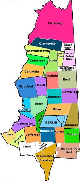
TOWNS
/ CITIES IN COOS COUNTY, New Hampshire
BERLIN
- Brief
History: Incorporated 1829; First granted in 1771 as
Maynesborough, after Sir William Mayne, an associate of
Governor John Wentworth in the West Indies trade. The area
was not settled by the original grantees, and the town was
renamed Berlin in 1829 by new settlers from Berlin, Massachusetts.
Berlin was incorporated as a city in 1897. It is the northernmost
city in the state, and includes the village of Cascade.
- Villages
and Place Names: Cascade, Berlin Mills
- Profile
& Statistics: Berlin,
New Hampshire
- GOVERNMENT:
- OTHER
WEB SITES:
- Genealogy:
- History
& Genealogy: Berlin, N.H. - This history
contains the geography and list of early settlers, action
of the first town meeting, list of 1829 residents and
their birth dates, names of voters in 1837, 1847 and
1857, early businesses, churches, societies, buildings,
early town officers, early roads and bridges, early
merchants and hotels, unusual phenomenon, and burial
places, physicians and lawyers; Brief biographies and
genealogies include those of William Sessions, Simon
Evans, Joseph Wheeler, Samuel S. Thompson, Samuel Blodgett,
Thomas Wheeler, Daniel Davis, Joseph Blodgett, John
Chandler, Lorenzo Mason; more extensive biograpies and
genealogies of Daniel Green and the Green Family, Amos
Green, Sullivan Dexter Green, Dexter Green, Reuben Hobart
Wheeler, Henry Hart Furbish, and Eugene William Scribner
(among others) -- TXT file
- Book:
History of Berlin NH,
from The History of Coos County, New Hampshire, by Georgia
Drew Merrill, 1888 (Internet Archive)
- Annual
city report, Berlin, New Hampshire, years 1882,
1893, 1898-1899, 1901, 1916-1917, 1919, 1921-26, 1929,
1932-1937, 1939-1941, 1945, 1947-1948, 1953, 1955, 1963-1965,
1970, 1973, 1975-1981 1983-85, 1988-89, 1990, 1996-98,
2000-2002 [including Vital Records]
- Earl
Silas Tupper (inventor
of Tupperware),
born
in Berlin NH in 1907
- Coos
County Archives -
USGenWeb
- Website:
Berlin History Online -
(unsure of sources of this but great photographs, always
a bit leery when people don't ID themselves.
- History
& Biography: New
Hampshire's Record-Breaking State Representative and
"Grand Dame": Hilda C.F. (Johnson) Brungot
(1886-1982) - Blog: Cow Hampshire
- One
Upon A Berlin Time
- Stories of Berlin's History & Photographs [Archived
version]
Genealogy:
Family Group Sheets of Hilda
C.F. Johnson and Sivert
"Sam" M. Brungot
Photographs
of Hilda C.F. (Johnson) Brungot, courtesy of George
Brungot her grandson.
Photographs/Postcards
& Multi-media:
MAPS:
CAMBRIDGE (an unincorporated
township)
HISTORY:
- Cambridge
is an unincorporated township, located on Umbagog
Lake, one of the bodies of water that separate Maine
from New Hampshire. In 1880 the census was thirty-six. Umbagog
Lake State Park is located here.
- CAMBRIDGE,
(from
1817 Gazeteer of New Hampshire) an uninhabited township
in Coos county, situated at the S. end of lake Umbagog and
bounded N. by Errol, E. by the District of Maine, S. by
Paulsburgh and Success, and W. by Dummer. Incorporated 1773,
containing 23,160 acres. Androscoggin river passes through
the W. part of this town.
- Cambridge
is a township in Coos County, in the Berlin metro area.The
latitude of Cambridge is 44.659N. The longitude is -71.109W.
It is in the Eastern Standard time zone. Elevation is 1,529
feet. The population, at the time of the 2000 census, was
10, and at the time of the 2010 census was 8 (four households).
ADDITIONAL
DETAILS:
- Umbagog
Lake State Park, on Route 26 in Cambridge NH is one of the
more recently acquired parks in the NH state system. The
Division began managing the park in 1998. The park includes
a base park campground with 35 sites with electrical and
water hook-ups available, three cabins, and 34 remote campsites
in isolated locations around Umbagog Lake accessible only
by boat. The park offers a beach area for swimming, fishing,
wildlife viewing, and boating. Canoe, kayak, rowboat, are
offered as well as transportation for remote site campers.
Boats launch and fuel sales are available, as well as a
park store. Wildlife viewing includes a variety of birds,
deer, and moose.
PHOTOGRAPHS:
MAPS:
CARROLL
[including Twin Mountain and Bretton Woods]
History:
Incorporated 1882. Originally granted as Bretton Woods in
1772, for Bretton Hall, an estate of Governor John Wentworth.
The town was renamed Carroll in 1832, for Charles Carroll
of Maryland, a signer of the Declaration of Independence.
The town includes the villages of Fabyan's, Bretton Woods,
and Twin Mountain. Bretton Woods is home to the Mount Washington
Hotel, site of the July 1944 International Monetary Conference
that resulted in the creation of the International Monetary
Fund and the World Bank. Nearby is Mount Washington’s
Cog Railway, the world's first mountain-climbing cog railway,
in operation since 1869.
Villages
and Place Names:
Bretton Woods, Fabyan, Quebec Junction, Twin Mountain,
Crawford House
GOVERNMENT:
- Official
Twin Mountain [Carroll] Web Site
- Government:
Carroll,
NH
- Online
Book: Annual
Report of the Town of Carroll, New Hampshire, including
vital records, births, marriages and deaths, for the Years:
1898, 1903, 1925-1927, 1935-1937, 1941-1975, 1977-1982,
1983-1986, 1988-2002.
PROFILE
& STATISTICS:
GENEALOGY
& HISTORY:
- History
& Genealogy:
History
of Carroll, N.H. - TXT file - This history includes
geography, early names, pioneer settlers and their origins,
roads, mills, organization of the town, record of the first
and early town meetings, first resident's inventory in 1883
(names only), populations, early religion, post officers,
manufacturers, merchants; early hotels and inns including
Fabyan's, Crawford House, Twin Mountain House, Pleasant
View House, the Mountain Pleasant House, and the White Mountain
House; complete biographies/early family trees of Abel Crawford
and descendants, and Capt. Eleazer Rosebrook and descendants;
the history has early ancecdotes about the early settlers
and their times.
- Book:
History of Carroll NH,
from The History of Coos County, New Hampshire, by Georgia
Drew Merrill, 1888 (Internet Archive)
- Article:
When
Frankenstein Roamed the White Mountains (Story about
artist Godrey Nicholas Frankenstein, and Frankenstine Trestle)
- Blog: Cow Hampshire
- Article:
The
Ghost of Mount Washington Hotel, Bretton Woods NH
- Blog: Cow Hampshire (includes genealogy of the Stickney
and Foster families)
- Historic
Marker: Bretton
Woods Monetary Conference
- Historic
Marker: Mt.
Washington Hotel, plus photos of the hotel
- History:
Bretton
Woods system of international economic management
PHOTOGRAPHS
& MULTI-MEDIA:
BUSINESS:
MAPS:
CLARKSVILLE
History:
Incorporated 1853. Part of a large tract granted to Dartmouth
College, portions of the land were sold to raise cash for
the college. Purchased by Joseph Murdock of Norwich, Vermont,
and Benjamin Clark of Boston, and cleared for settlement by
the Clark family, the town was named Clarksville. It was also
known as Dartmouth College Grant until 1872. The town is south
only to Pittsburg.
Villages
and Place Names: formerly known as Dartmouth College Grant
PROFILE
& STATISTICS
GOVERNMENT:
GENEALOGY
& HISTORY:
- History
& Genealogy: Clarksville, N.H. - This
document includes the geography and early history of Dartmouth
College Grant, later Clarksville, including early settlers,
early town records, marriages in Clarksville 1827-1831,
and partial genealogies/biographies of Gideon Tirrill, Joseph
Wiswall, John Comstock, Benjamin Clark Wiswall, and John
Keysar - Txt file
- Book:
History of Clarksville NH,
from The History of Coos County, New Hampshire, by Georgia
Drew Merrill, 1888 (Internet Archive)
PHOTOGRAPHS:
MAPS:
COLEBROOK
History:
Incorporated 1796. First granted in 1762, the territory was
named Dryden, after English poet and playwright John Dryden.
Due to the inability of grantees to settle the area, it was
regranted in 1770 to new colonizers, who renamed the grant
Colebrook, after Sir George Colebrooke of England, the East
India Company’s chairman of the board.
Villages
and Place Names: Kidderville, Upper Kidderville, Factory
Village
GOVERNMENT:
PROFILE
& STATISTICS
GENEALOGY
& HISTORY:
- History
& Genealogy, Colebrook NH - Txt file
- A description and topography of Colebrook NH; brief
biographies of original proprietors and early settlers including
Joseph Goddard, Isaac Covil, John Whittemore, Ebenezer Hill,
Hosea Aldrich, Thomas Atherton, Joseph Gleason, Edmund Chamberlain,
Capt. Benjamin Buel, David Titus, Sylvanus Noyes, Frederick
G. Messer, Ethan Colby, Caleb Little, Ebenezer Little, Alfred
Loverin, Charles Thompson, Timothy Holton, Joseph Loomis,
Benjamin Whittemore, John F. Gould, Noah Cummings, Samuel
Harriman, Daniel Hutchinson, Benjamin R. Gilman, Jonas Rolfe,
Archelaus Cummings, Benjamin Gathercole, Levi O. Hicks and
others; early merchants; 1816 list of residents; Education;
Societies; Physicians; Post Offices, Mills, Churches; Various
civil and town records from 1801-1830; Biographies/Genealogys:
the Parsons Family, Dr. Lyman Lombard, Col. Hazen Bedel,
Hon. Sherburn R. Merrill, Seneca Sargent Merrill, and Samuel
Kelly Remick.
- Book:
History of Colebrook NH,
from The History of Coos County, New Hampshire, by Georgia
Drew Merrill, 1888 (Internet Archive)
- Colebrook
Village Cemetery, Colebrook NH - some cemetery inscriptions
- A
few facts about Colebrook NH - from official Colebrook
web site
NEWS:
PHOTOGRAPHS:
- COLEBROOK,
Town Hall
- Colebrook:
Royal's Store (left to right, Ethan Titus, Ernest F.
Royal, Guy B. Trask, Ed Atherton and Guy Royal; the child
was Russell Simpson) - JPG file; reportedly the store was
removed in 1970.
- Colebrook
residents, circa 1905 (left to right, Jason Dudley,
Daniel Cummings, and Edward Hull. All three held town offices
- JPG file
- 1913
photograph of Harry K. Thaw (famous for the "Girl
in the Red Velvet Swing" murder of Stanford While)
is excorted by Sheriff Holman Drew in Colebrook, after his
capture - JPG - [For more history of this sensational
murder, trial and outcome, see Harry
K. Thaw
- Poore
Farm, Colebrook NH - Museum
BUSINESS:
MAPS:
COLUMBIA
History:
Incorporated 1797. First chartered in 1762, and named Preston
for Richard Graham, Viscount Preston of Scotland. The town
was regranted in 1770 due to the settlers' failure to meet
the terms of the grant, and renamed Cockburntown, after Sir
James Cockburn of Scotland. It kept that name until 1811,
when Governor John Langdon renamed the town Columbia in the
spirit of patriotism preceding the War of 1812.
Villages
and Place Names: Bungy, Cones, Georges, Meriden Hill,
Tinkerville
GOVERNMENT:
- Government:
Columbia
NH
- Columbia
Town Clerk
RR 3
Colebrook, NH 03576-9803
(603) 237-5255
PROFILE
& STATISTICS
GENEALOGY
& HISTORY
- History
& Genealogy, Columbia NH - Txt file
- The early history of Cockburn, later Columbia NH including
early pioneers, schools, churches merchants, grist and saw
mills, including the families of Abel Larnard, Abel Hobart,
William Wallace, Noah Buffington, Philip Jordan, and Benjamin
Jordan (and others).
- Book:
History of Columbia NH,
from The History of Coos County, New Hampshire, by Georgia
Drew Merrill, 1888 (Internet Archive)
PHOTOGRAPHS:
MAPS:
DALTON
History:
Incorpoated 1764. Once a part of Littleton, the town went
through several name changes. Starting in 1764 as Chiswick,
after the Duke of Devonshire's Castle, in 1770 the name changed
to Apthorp, honoring the Apthorp family. Finally in 1784,
it was changed to Dalton, for Tristram Dalton, one of New
England's foremost colonial merchants.
Villages
and Place Names:
Cushman, Scott
GOVERNMENT
PROFILE
& STATISTICS
HISTORY
& GENEALOGY:
- History
& Genealogy of Dalton, NH
- TXT file - Includes the early history of Dalton NH: Early
history and naming of the town of Dalton NH; information
and biographies of originators and early settlers including:
Tristram Dalton, Moses Blake, Walter Bloss; the First Town
Meeting [in 1808]; Lands and Livestock owners in 1809; Names
mentioned in the town meeting records of 1809-1842; Early
births from 1785-1811; Early marriages in 1810 & 1814;
Early residents taxed in 1809; Ear-marks of 1809-1813; Early
Merchants; Description of Dalton in 1821; Early Inn-Keepers;
Roads; Residents in 1849; Mines; Murder in 1877; Physicians;
Brief Personal Sketches of: John Blakeslee Sr. and family,
John Tenney, William Wallace, John Crane & Family, Rev.
Samuel H. Partridge, Andrew Lang and Family, Jonathan Scott,
Jacob Barrows, Jonathan Fisher, Alvin & Asa Taylor,
David Sumner & Sumner Family, Lorenzo Farr, The Brooks
Family (Benjamin Sr. & Jr.), Horace Cushman/Cashman,
John Ladd & Family, Bert Taylor; Ecclesiastical (Church)
History and early members; Meeting House history; Civil
List from 1808-1826.
- Book:
History of Dalton NH,
from The History of Coos County, New Hampshire, by Georgia
Drew Merrill, 1888 (Internet Archive)
- A
Brief History of Dalton NH - Dalton NH Historical
Society
- Dalton
Historical Society
- Cemeteries
in Dalton NH
PHOTOGRAPHS:
MAPS:
DIXVILLE
History:
Dixville, has an area of 31,023 acres, and is situated immediately
east of Colebrook, Columbia and Stewartstown.. It received
its name from Colonel Timothy Dix, father of General John
A. Dix, the noted war governor of New York, to whom the township
was granted in 1805. John Whittemore of Salisbury came to
Dixville in 1812, and was employed by Ezekiel and Daniel Webster,
attorneys for the Dix Family. John Whittemore farmed and ran
a wayside inn here. Dixville's famous scenic "Notch,"
and the state forest area, along with the Balsams Hotel resort
continues to attract visitors from around the world.
Villages
and Place Names: Dixville Notch
GOVERNMENT:
GENEALOGY
& HISTORY:
- History
& Genealogy of Dixville NH - brief history
including mention of the DIX family, John Whittemore family,
George Parsons and the "Dix House." - TXT file
- Book:
History of Dixville NH,
from The History of Coos County, New Hampshire, by Georgia
Drew Merrill, 1888 (Internet Archive)
- Online
Book: Farrar's
illustrated guide book, to Rangeley, Richardson, Kennebago,
Umbagog, and Parmachenee lakes, Dixville notch, and Andover,
Me., and vicinity .. - Farrar, Charles Alden John, 1876
- Genealogy:
Whittemore
Family of Coos County NH
PHOTOGRAPHS:
MAPS:
DUMMER
History:
Incorporated 1848. First granted in 1773, Dummer was named
for Governor William Dummer of Massachusetts, whose achievements
included a peace treaty with the Indians which lasted nearly
twenty years. Fort Dummer, one of New England's earliest forts,
was also named for Governor Dummer.
Villages
and Place Names: Paris
GOVERNMENT:
PROFILE
& STATISTICS:
HISTORY
& GENEALOGY:
- History
& Genealogy of Dummer NH - This
document describes the geography,; incorporation of the
town; early settlers including William Leighton, Charles
Bickford, James H. Horn, Hezekiah Cloutman, Peter Leavitt,
Daniel Forbush (Furbush), Charles Newell, Jothan Lary, Aaron
Wight, William Sessions, William Lovejoy, John M. Bickford,
Daniel Forbush Jr., John B. Lovejoy, Thomas Wentworth, John
R. Briggs, Horace Chandler, Leonard E. Dunn, and others;
Inventory and Polls of Property 1846; Petition for Incorporation,
partial Civil List; Schools; Ministers (Francis Lang), Biographical
Sketch of Isaac Carlton Wight and Family - TXT file
- Book:
History of Dummer NH,
from The History of Coos County, New Hampshire, by Georgia
Drew Merrill, 1888 (Internet Archive)
- Annual
Reports of the Town of Dummer, NH, for years 1893, 1902,1925-1927,
1929, 1937-1967, 1969-1974, 1976-1985, 1996-2001, 2004-2008
(Including Vital Statistic)
MAPS:
ERROL
History:
Incorporated 1836. First chartered in 1774, Errol was named
for James Hay of Scotland, fifteenth Earl of Erroll, and owner
of Linlithgow Castle, the birthplace of Mary, Queen of Scots,
and King James V. Sitting on the northern end of Maine border,
this sparsely populated town is a popular vacation site for
snowmobilers. Errol is home to half of Umbagog Lake, and has
more inland water area than any town in Coos County.
Villages
and Place Names: none known
GOVERNMENT:
PROFILE
& STATISTICS:
HISTORY
& GENEALOGY
- History
of Errol, NH
- A
general description and early history of the town of Errol
NH including geography, information about The Androscoggin
River Improvement Company, the Akers House, the Umbagog
House, the Errol Dam Company, early petitions, first town
meetings, early town officers; list of voters in 1837 -
TXT File
- Book:
History of Errol NH,
from The History of Coos County, New Hampshire, by Georgia
Drew Merrill, 1888 (Internet Archive)
PHOTOGRAPHS
MAPS:
GORHAM
History:
Incorporated 1836. First chartered as a part of Shelburne
in 1770. The town was incorporated in 1836 and renamed Gorham
at the suggestion of Sylvester Davis, a resident from Gorham,
Maine, and a relative of the Gorham family who founded that
town in 1764.
Villages
and Place Names: Mount Washington, Upper Village, Cascade
GOVERMENT:
PROFILE
& STATISTICS
GENEALOGY
& HISTORY:
- History
& Genealogy of Gorham NH - This
document describes the geography and topography, early settlers
including Stephen Messer and family, Henry Goodno and family,
Joseph Jackson and family, and Simon Evans among others;
population and some residents in 1815; arrivals in 1821
and later including Hezekiah Orway; early schools and churches;
the "Great Freshet of 1826;" residents in 1836;
first mills; act of incorporation; the first town meeting;
taxpayers of 1836-1850; Gorham residents in the Civil War;
Railroads; Gorham Village; Businesses and Merchants; Lawyers
and Physicians; Hotels and Inns; Societies; Post office;
Mascot Mine; Biographical Sketches of Andrew G. Lary, John
Raymond Hitchcock, Captain Warren Noyes, Timothy H. Hutchinson,
Virgil H. Twichell, and Nathaniel T. True
- TXT file
- Book:
History of Gorham NH,
from The History of Coos County, New Hampshire, by Georgia
Drew Merrill, 1888 (Internet Archive)
- Coos
County Archives -
USGenWeb
PHOTOGRAPHS:
MAPS:
GROVETON
Groveton
is a village in NORTHUMBERLAND
- SEE below
JEFFERSON
History:
Incorporated 1796. First granted in 1765, the location was
so deep in unexplored territory that few took up their claims.
One who did was Colonel Joseph Whipple of Portsmouth, who
cut trails through the forests to build a manor house. He
named the town Dartmouth after William Legge, Earl of Dartmouth
and patron of Dartmouth College. Brother to William Whipple,
signer of the Declaration of Independence, Colonel Whipple
renamed
the town Jefferson in 1796, four years prior to Thomas Jefferson's
election as President.
Villages
and Place Names: Baileys, Highlands, Jefferson Highlands,
Riverton, Starr King,
Waumbeck Junction, Cherry Mountain, Meadows
GOVERNMENT:
PROFILE
& STATISTICS:
GENEALOGY
& HISTORY:
- Genealogy
& History:
Jefferson
NH - TXT file
- Early history of the town, list of first settlers
and tax list; early town officers, article of incorporation,
roads and taverns; merchants, churches, mills and hotels;
legends and lore of the White Mountains including, "Granny"
Deborah Vicker Stalbird, the "Pond of Safety,"
and "Roger's Rangers and St. Francis statue."
Also included are the biographies and genealogies of the
following: -- Professor Thaddeus Sobieski Lowe, James Hight,
Hon. Nathan Randall Perkins, Col. Joseph Whipple, Daniel
Austin, Benjamin Hunking Plaisted, Benjamin Hicks.
- Book:
History of Jefferson NH,
from The History of Coos County, New Hampshire, by Georgia
Drew Merrill, 1888 (Internet Archive)
- Jefferson
NH History with photographs - from the Granite State
Monthly magazine 1898.
- Granny
Stalbird Story & Descendants [ Deborah Vickery(y)
aka Mrs. RIchard "Granny" Stalbird - from Cow
Hampshire blog
- Biography
& Genealogy: Jefferson
New Hampshire Inventor & Aeronaut, Prof. Thaddeus S.C.
Lowe (1832-1913) - blog, Cow Hampshire
- Family
Tree: Plaisted
Family of Jefferson NH
- History:
Thaddeus
Lowe, Jefferson's famous son (also see the History
above)
PHOTOGRAPHS:
MAPS:
LANCASTER
History:
Incorporated 1763. Lancaster was an early settlement on the
northern portion of the Connecticut River subject to many
Indian troubles. The town was named for Lancaster, Massachusetts,
hometown of an early settler. Reverend Joshua Weeks, a grantee
of the town, was among the group of explorers who named the
mountains in the Presidential Range. Other grantees included
Nash and Sawyer, who discovered the "White Mountain Notch,"
making a shorter route to Portland possible.
Villages
and Place Names: Coos Junction, Grange, Lost Nation, South
Lancaster
GOVERNMENT:
PROFILE
& STATISTICS:
GENEALOGY
& HISTORY:
- Genealogy
& History:
History
of Lancaster NH--TXT file. This is an EXTENSIVE
history that includes the list of original proprietors,
early marriages, town description and populations over the
years, early industry and merchants (up to the mid 1800's),
early town officers, participants in the American Revolution
and Civil War, the origins of churches, hotels, library,
and organizations, and includes biographies of physicians
and lawyers, along with biographies and partial genealogies
of the following individuals and their families: Frank Bugbee,
M.D., Alexander Thompson, Anderson J. Marshall, Frank Smith,
Capt. Thomas Dixon, George Van Dyke, George Roscoe Eaton,
Hosea Gray, Persis Weeks Rice, Rev. James Barnes Morrison,
William Dennis Weeks, James Wingate Weeks, Sarah Weeks Wilder,
Mary Weeks Eastman, Nelson Kent, James Brackett Weeks, John
Wingate Weeks, Capt. John Weeks, Dr. John Weeks, Capt. Joshua
Weeks, Hon. Henry O. Kent, Jacob Kent, Richard Peabody Kent,
Ziba Lynds, Zadoc Cady, Seth Savage, Col. Ephraim Cross,
Royal Joyslin, John H. White, Major Moses White, James Perkins,
Colonel Stephen Wilson, Titus Olcott Brown, Adino Nye Brackett,
Joseph Brackett, Major Jonas Wilder, Lieutenant Daniel Stanley,
Edwards Bucknam, and Captain Emmons Stockwell; includes
many more dates of birth and death of inhabitants not listed
here.
- Online
Book: The
Lancaster sketch book - Chase, Persis F, 1887
- Online
Book: History
of Lancaster, New Hampshire - Somers, Amos Newton, 1898
- Online
Book: The
Centennial celebration of the settlement of the town of
Lancaster, N.H., July 14, 1864 - Lancaster (N.H.)
- Online
Book: Address
of President Harding at Lancaster, N.H., August 4, 1921
.. (Volume 1) - Harding, Warren G. (Warren Gamaliel)
- Biography:
Lancaster NH’s John Wingate Weeks (1860-1926)
— the “Weeks” behind the “Weeks Act”
from BLOG: Cow Hampshire
- Biography:
Lancaster
New Hampshire Punk Rock Musician, Kevin Michael "G.G."
Allin (1956-1993)
- blog: Cow Hampshire
- Pinkham
Family of Lancaster NH,
from
GoogleBooks, "Richard Pinkham of Old Dover, New Hampshire."
- Book:
History of Lancaster NH,
from The History of Coos County, New Hampshire, by Georgia
Drew Merrill, 1888 (Internet Archive) [includes 1826 map
of Lancaster NH].
- Name
Index for Book: "150th
Anniversary of Lancaster" - USGenWeb
- Name
Index for Book: History
of Lancaster NH (1900) - USGenWeb
- Brief
History of Lancaster NH
PHOTOGRAPHS:
- Historic
Building: Main
Street Bridge, Spanning Israels River, Lancaster - American
Memory/HABS
- Historic
Marker: Wilder-Holton
House
- Lancaster NH
- Weeks
State Park Mansion, Lancaster NH
- Scenes
from Prospect Mountain, Lancaster NH
- Photograph:
Wilder-Holton
House of Lancaster NH
- Photograph:
LANCASTER,
District Court building
- Photograph:
1913
Lancaster NH, Methodist Church in foreground
- Photograph:
Covered
Bridge, Lancaster NH
- Mechanic
Street Bridge, Lancaster
- Mt.
Orne Bridge,
Lancaster
- A
"Coaching Parade" in Lancaster, circa 1895
- JPG
- Views
of Lancaster NH from "The Mansion" at Weeks
State Park
- Circa
1920 photograph of Robert Addley, blacksmith of Lancaster
in that year. He was born in Canada, and had a wife Ella,
and daughter Evelyn. - JPG
- Lancaster:
Photograph - Jacob Benton (1814-1892) born in Waterford,
Caledonia County, Vt., August 19, 1814, son of Samuel Slade
& Esther (Prouty) Benton; engaged in teaching for several
years, studied law, admitted to the bar in 1843 and commenced
practice at Lancaster, NH; Republican. Member of New Hampshire
state house of representatives, 1854-56; delegate to Republican
National Convention from New Hampshire, 1860; U.S. Representative
from New Hampshire 3rd District, 1867-71. Died in Lancaster,
Coos County, N.H., September 29, 1892. Interment at Summer
Street Cemetery, Lancaster, N.H.; was a Union brigadier
General commanding volunteers from NH. In 1850 & 1860
Lancaster, Coos Co NH, attorney single; married 12 Dec 1860
in Lancaster, Coos Co NH to Louise/Louisa Dwight. No known
children. [link dead Oct 2017]
NEWS:
MAPS:
MILAN
History:
Incorporated in 1824. First named Paulsbourg in 1771, after
Paul Wentworth, the governor's cousin. Among the first grantees
were relatives of the Harris family, who had established one
of the first woolen mills in America at Harrisville. In 1824,
Governor Levi Woodbury, who was interested in expanding wool
culture in New Hampshire, authorized naming the town in honor
of Milan Harris. In the middle 1800's, there was a large vein
of
gold discovered in the hills, which was mined for several
years. Milan is the site of the Berlin Ski Jump.
Villages
and Place Names: Copperville, West Milan
GOVERNMENT:
PROFILE
& STATISTICS:
HISTORY
& GENEALOGY:
- History
& Genealogy of Milan, NH - Contains
information on the geography of Milan, original incorporation,
early settlers: John Ellingwood, Isaac Harris, Daniel G.
Ellingwood, Moses Hogdon, Amasa Fogg, Abner Hinds, George
T. Roberts, Isaac Hagar, Reuben Sargent, Sylvanus and Moses
Robbins, Emerson Cole, Reuben Hobart, the Wight family,
Edward Richardson, Isaac Stearns, Samuel Crafts, James H.
Horn, Peter Wheeler, the Twitchel Family, and others; names
of settlers in the town inventory of 1825; first town meeting;
partial civil list starting in 1825; first mills; Merchants;
Early Church History; Milan Mine history; businesses starting
in 1838; Milan and the War of the Rebellion (Civil War);
Physicians including Dr. Ozmon M. Twitchell, Dr. William
Berry Lapham, Don A. Robinson, M.D., Dr. Richard H. Meserve,
J.D. Holt, M.D., Dr. Joseph J. Cobb, and others; Biographical
Sketches of Adams Twitchel,
James J. Phipps, Peter A.G.W. Phipps, and Hon. Liberty Haven
Hutchinson
- TXT file
- Book:
History of Milan NH,
from The History of Coos County, New Hampshire, by Georgia
Drew Merrill, 1888 (Internet Archive)
PHOTOGRAPHS:
MAPS:
MILLSFIELD
History:
was granted to Sir Thomas Mills, George Boyd and others on
March 1, 1774. In 1858 there was but one house in the town.
In 1870, there were 28 inhabitants; in 1880 sixty two with
a valuation of nearly $60,000; in 1887 thirteen families were
resident. Millsville contains twenty-three thousand acres,
but the northern part is mountainous. Clear stream waters
its northern extremity, and Phillips Rivers with several smaller
streams the other parts of the town. It is bounded north by
Dixville, east by Errol, south by Dummer, west by Odell and
Dixville.
Villages
and Place Names: none known
PROFILE
& GOVERNMENT:
Town
of Millsfield, NH
HISTORY
& GENEALOGY:
PHOTOGRAPHS:
MAPS:
NORTHUMBERLAND
History:
Incorporated 1779. The town was first named Stonington in
1761, probably due to Governor Benning Wentworth's shipbuilding
interests in Stonington, Connecticut. It was renamed Northumberland
in honor of Hugh Smithson, first Duke of Northumberland. The
Duke's son, James Smithson, is remembered for leaving a legacy
of more than a half million dollars for the founding of the
Smithsonian Institution. Most of Northumberland's residents
live in the village of Groveton.
Villages
and Place Names: Groveton (is a village in Northumberland)
The community was named for a grove of maple trees growing
near the railroad depot
GOVERNMENT:
- Government:
Contacts
in Northumberland NH
- Contacts
for Groveton NH Officials
- Groveton
Library
22 State St
Groveton, NH 03582
- St
Francis Xavier Parish
29 State St
Groveton, NH 03582
- Northumberland
Historical Society
2 State Street, Groveton, NH
Phone: 603-636-1450
- Old
(1799) Meeting House
State Street, Groveton, NH
Phone: 603-636-1450
PROFILE
& STATISTICS:
GENEALOGY
& HISTORY:
- Genealogy
& History of Northumberland NH - TXT file.
Early history of Northumberland, N.H. including the
naming of the town and its description; Names of the original
grantees of Stonington (later Northumberland) in 1771; Brief
biographies of the first settlers including Thomas Burnside,
Daniel Spaulding, Capt. Jeremiah Eames; First Bridges, Roads
and Ferries; Early town petitions from 1780-1799 and signer's
names; Incorporation of the Town and officers from 1780-1793;
Early Ecclesiastical (Church) History, Clubs and Societies;
Fort Wentworth and the Revolution; Soldiers from Northumberland
in the War of 1812 and Mexican War; Brief Biographies of
Francis Willson, John M. Tillotson; Schools, Physicians,
Manufacturing; Merchants and Railroads: Biographical Sketch
of Captain Gilbert Soule, and his family genealogy.
- Book:
History of Northumberland NH,
from The History of Coos County, New Hampshire, by Georgia
Drew Merrill, 1888 (Internet Archive)
- Northumberland
Cemetery burials (by location, not alphabetized) - from
the official town web site.
- Genealogy:
Cemeteries near Groveton NH
- NH
WWI Military: Heroes of Groveton & Northumberland -
blog, Cow Hampshire. A list of all names engraved on WWI
monument who served from Groveton-Northumberland NH, and
biographies on those who died during World War One. (coming
soon)
- Wausau
Paper Company History
- History
- Fort Wentworth, Groveton NH - (1755 or 1759 ?, 1775 -
1778), near Groveton Said to have been originally built
by Roger's Rangers as
they returned from an expedition to Canada. There was
a work built here by the local militia during the American
Revolution. A stone monument marks the possible site of
this fort near a cemetery near the junction of the Connecticut
and Ammonoosuc Rivers.
- William
E. Holyoke, Medal of Honor Winner, b. Groveton NH
PHOTOGRAPHS:
MAPS:
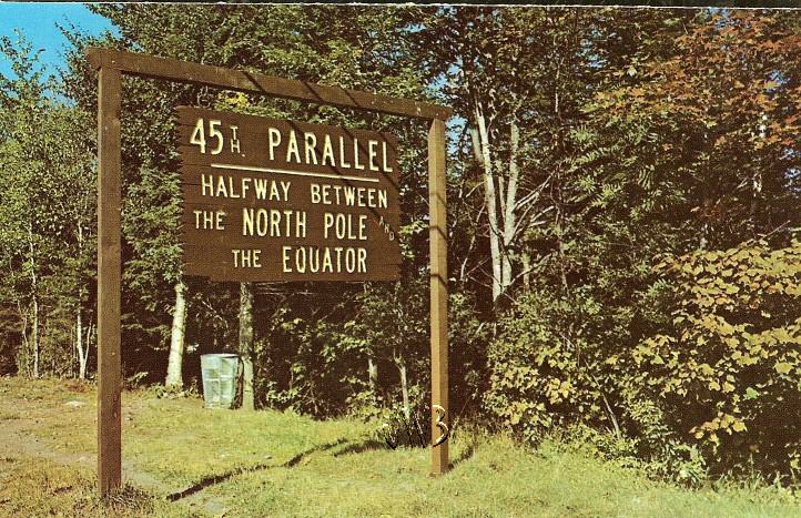
PITTSBURG
History:
Incorporated in 1840. Originally known as Indian Stream,
Pittsburg is distinguished by having the largest amount of
land area of any township. Covering the entire top of the
state, the area includes Lake Francis, the three Connecticut
Lakes, and the international boundary post erected on the
45th Parallel, halfway between the North Pole and the Equator.
For a while, starting in 1832, Pittsburg was home to the Indian
Stream Republic, a colony that established its own constitution
and separate government. The Indian Stream Republic existed
for over four years, then became a part of New Hampshire,
and was incorporated with Pittsburg in 1840. The name Pittsburg
is in honor of William Pitt, Prime Minister of England.
Villages
and Place Names: Happy Corner, Idlewilde, The Glen.
Regarding
the Indian Stream Republic:
Living near the uncertain, remote border between Canada and
New Hampshire, the 360 inhabitants of Indian Stream established
a provisional, free republic with a constitution, bicameral
legislature, and 40-man army (1832-35). Some inhabitants wanted
to be Canadians; others wished to join New Hampshire, which
(along with the US government) rejected Indian Stream's independence.
In 1835, pro-Canadians attacked and routed two sheriffs from
New Hampshire, which finally, (November) sent in 50 militiamen,
who easily won the "war" without any casualties.
Indian Stream later (1836) united with New Hampshire.
GOVERNMENT:
PROFILE
& STATISTICS:
HISTORY
& GENEALOGY:
- 1906
Statistics (Births, Marriages, Death) in Pittsburg NH
and the Town Report
- 1909
Statistics (Births, Marriages, Deaths) in Pittsburg
NH and the Town Report
- 1922
Statistics (Births, Marriages, Deaths) in Pittsburg
NH and the Town Report
- 1938
Statistics (Births, Marriages Deaths) in Pittsburg NH
and the Town Reports
- 1939
Statistics (Births, Marriages, Deaths) in Pittsburg
NH and the Town Reports
- History
& Genealogy of Pittsburg NH -
Geography
and history of Pittsburg and "Indian Stream Territory,"
including early town officers, first settlers, early churches
and schools
-- TXT file
- Book:
History of Pittsburg NH,
from The History of Coos County, New Hampshire, by Georgia
Drew Merrill, 1888 (Internet Archive)
- History
& Old Photographs of Pittsburg NH
- New
Hampshire Missing Places: Indian Stream Republic (1829-1836)
- from my blog "Cow Hampshire"
- Biography--New
Hampshire Missing Places: Camp
Otter in Pittsburg, Coos County [includes genealogy
of the Currier family]. Blog: Cow Hampshire
- Genealogy--The
Baldwin Family of Pittsburg, Coos County, New Hampshire
- Blog, Cow Hampshire
REFERENCE:
PHOTOGRAPHS/MEDIA:
MAPS:
RANDOLPH
History:
Incorporated in 1824. In the charter of 1772, this town was
named Durand, after John Durand, a member of the London Board
of Trade and an associate of Governor John Wentworth. In 1824,
Governor Levi Woodbury renamed it Randolph, in honor of his
friend John Randolph of Virginia. Randolph was a long-time
member of the House of Representatives, an advocate of states'
rights, and a descendant of Pocahontas. Randolph is located
in Coos County between Jefferson Highlands and Gorham on US
Highway 2 near Moose Brook State Park.
Villages
and Place Names: Appalachia, Bowman, Randolph Hill
GOVERNMENT:
Randolph
Town Clerk
RR1, Box 1429, Durand Road
Berlin, NH 03570
(603) 466-5771
PROFILE
& STATISTICS
HISTORY
& GENEALOGY:
- History
& Genealogy of Randolph NH - This document
includes the early history and incorporation of Randolph
(formerly Durand); The location of the earliest settlers
including Benjamin Ockington, Augustus Stephen, Jesse Bumpus,
Samuel Rogers, James Hill, John Bowman, Hubbbard Hunt, Robert
Ingalls, Clovis Lowe, Caleb Wilson, Stephen Gilson, Elaska
Jackson, William Watson, Anthony Vincent, Joseph Wilder,
James Gray, Jonas Green, Titus O. Brown, Henry Goodenough,
Abraham William, Jonathan Goodin, John Wilson, Amos Peabody,
Cornelius Bass, Elizur Evans, Joshua Holmes, Robert Leighton,
Ithiel Scales, Samuel Emery, Mark Pitman, William Felker,
Jacob Morse, and others; First Town Meeting and early officers;
Schools, Ministers and Churches; War Record - TXT file
- Book:
History of Randolph NH,
from The History of Coos County, New Hampshire, by Georgia
Drew Merrill, 1888 (Internet Archive)
- Article:
Randolph
New Hampshire's Wellesley College President and Director
of WAVEs: Dr. Mildred Helen (McAfee) Horton (1900-1994)
- Blog: Cow Hampshire
PHOTOGRAPHS:
MAPS:
SHELBURNE
History:
Incorporated in 1821. First chartered in 1769, this town was
named for William Petty Fitzmaurice, Earl of Shelburne. Lord
Shelburne was a supporter of independence for the American
colonies, and at his insistence, the king recognized the independence
of the United States. Remaining unsettled for quite some time
after the charter was made, the town was incorporated in 1821
when Shelburne voters chose to keep the name.
Villages
and Place Names: none known
GOVERNMENT:
PROFILE
& STATISTICS:
GENEALOGY
& HISTORY:
- Genealogy
& History of Shelburne NH - This
document includes a length poetic description of Shelburne,
its geography, the first grant of the town; original incorporators,
description of the original grant; information about the
early settlers including Hope Austin and family, Daniel
Ingalls and family, Fletcher Ingalls, Amos Peabody, Thomas
Green and family, Samuel Wheeler and family, Jonathan Evans,
Benjamin Clemens, Daniel Evans and family, Bazaleel Gates,
Simeon Evans, Jonathan Rindge, Jonathan Peabody and family;
Jonathan Lary, Peter Poor, Nathaniel Porter, the Head family,
Harvey Philbrook, Dr. Oliver Howe, Hiram Cummings and others;
Industries; Mills; early merchants; Roads and Bridges; Religion
and Meeting-House; Schools; White Mountain Stock Farm (Judge
Robert Ingalls Burbank); Lead Mine; Hotels; and Soldiers
in the Revolution, War of 1812 and War of the Rebellion
(Civil War); Early Town Clerks and Selectmen -
TXT file
- Book:
History of Shelburne NH,
from The History of Coos County, New Hampshire, by Georgia
Drew Merrill, 1888 (Internet Archive)
PHOTOGRAPHS:
MAPS:
STARK
Latitude:
44.600N
Longitude: -71.406W
History:
Incorporated 1795. First granted in 1774, this town was named
Percy, in honor of Hugh Smithson, Earl Percy and first Duke
of Northumberland. The town retained this name until 1832,
when in was renamed Stark in honor of General John Stark,
hero of Bunker Hill and the Battle of Bennington. New Hampshire
owes its motto, "Live Free or Die," to General Stark.
Stark, the first to carry the new thirteen-star American flag
into battle, wrote those words in July 1809, in commemoration
of the Battle of Bennington.
Villages
and Place Names: Crystal, Percy.
GOVERNMENT:
Stark
Board of Selectmen (for town records and vital statistics)
1189 Stark Highway
Groveton, NH 03582
(603) 636-2118
PROFILE
& STATISTICS:
HISTORY
& GENEALOGY:
- History
& Genealogy of Stark, NH - TXT file.
Description of Stark, N.H. and geographical areas such as
The Devil's Slide, the Devil's Hop-Yard, and Christine Lake
(formerly North pond); Soil and population; Minerals on
the Land; Naming of the Town; Signers of the Petition of
Incorporation in 1791; Names of Grantees; Early town meetings;
First Male Child born in town; Names of Early Settlers;
1803 List of Settlers; Early Births and Marriages (1790-1802);
Town of Piercy Civil List 1795-1803; 1809 List of Town Residents
Inventory; Churches, Schools, Town Hall & Library; Early
Manufacturers and Merchants; Brief Biographies of early
settlers: Caleb and Benjamin Smith; Joseph Leavitt, Cole
Family, Robert Pike, Aaron Jackson Smith,and others.
- Book:
History of Stark NH,
from The History of Coos County, New Hampshire, by Georgia
Drew Merrill, 1888 (Internet Archive)
PHOTOGRAPHS:
MAPS:
STEWARTSTOWN
Latitude:
45.006N
Longitude: -71.508W
History:
Incorporated 1795. First granted in 1770, this town was highly
disputed territory. Governor John Wentworth passed the grant
to developers, including Sir John Stuart, Lord Bute, for whom
the town was named Stuart. Following the Revolution when English
grants reverted to the colonies, the town was incorporated
as Stewartstown, using the original Scottish spelling. The
famous Penobscot Indian chief Metallak is buried in the town
cemetery.
Villages
and Place Names: Stewartstown Hollow, West Stewartstown
GOVERNMENT:
Stewartstown
Town Clerk
Rt 3 Washington St
W Stewartstown, NH 03597
(603) 246-3329
PROFILE
& STATISTICS:
HISTORY
& GENEALOGY:
- History
& Genealogy of Stewartstown NH - This
history includes names of the early settlers (prior to 1800,
and up until 1850's based on tax lists, ear mark books etc.),
early town records, first tavern licenses and innkeepers,
early manufacturers and merchants, early doctors and dentists,
churches, origin of pond/lake names, partial genealogies
and biographies of James Miner Hilliard, Hon. Amos Webster
Drew, Edwin W. Drew, Lyman Willis Alger, Fernando C. Jacobs,
Isaiah H. Pickard, and many others - TXT file
- Book:
History of Stewartstown NH,
from The History of Coos County, New Hampshire, by Georgia
Drew Merrill, 1888 (Internet Archive)
PHOTOGRAPHS:
- NH
Historic Marker: 45th Parallel, Stewartstown - As you stand
at this point on the 45th parallel you are halfway between
the Equator and the North Pole. Located on US 3, about
.5 mile north of West Stewartstown.

Postcard:
45th Paralell Marker, W. Stewartstown NH
- NH
Historic Marker: Metallak, Hunter, trapper, fisherman
and guide, well and favorably known by the region's early
settlers. "The Lone Indian of the Magalloway"
was the last survivor of a band of Abnaki inhabiting the
Upper Androscoggin. Blinded by accidents, Metallak died
a town charge in 1847 at the reputed age of 120. He is buried
in the North Hill Cemetery on road to the east. Located
to the east side of NH 145, about 1 mile north of Stewartstown
village.| Photograph
- Big
Diamond Pond, Stewartstown NH -
from greatnorthwoods.org
- Hurlburt
Swamp, Stewartstown NH
- Stewartstown
- a
circa 1903 camp on Big Diamond Pond - JPG
MAPS:
STRATFORD
Latitude:
44.655N
Longitude: -71.556W
History:
Incorporated 1773. First granted in 1762 to early settlers
mostly from Woodbury, Connecticut, this town was originally
named Woodbury. Indian troubles had many families forfeiting
their claims, and it was regranted in 1773 as Stratford, also
a town in Connecticut. The name is also in honor of Stratford-on-Avon,
Shakespeare's home. The entire tract was one of the largest
granted in New Hampshire, a total of 48,603 acres.
Villages
and Place Names: Beatties, Mapleton, Masons, North Stratford,
Stratford Center, Stratford Hollow, East Stratford
GOVERNMENT:
PROFILE
& STATISTICS:
HISTORY
& GENEALOGY:
- Cohos
Historical Society
- [on Facebook, old link dead] information about Bloomfield,
Brunswick, VT and Stratford NH.
- History
& Genealogy of Stratford NH
- TXT file -- Early history of Woodbury, later nown as Stratford;
includes early settlers, list of proprietors and early residents,
history of churches schools, attorneys, doctors, societies,
hotels, taverns, and businesses; biographies and genealogies
include those of several membersof the BALDWIN family, John
Holmes, Nahum Daniels Day, Joshua Marshall, Capt. Ephraim
Mahurin, Dr. Cyrus Carpenter, James Ogle, James Twohey (and
MANY more names).
- Book:
History of Stratford NH,
from The History of Coos County, New Hampshire, by Georgia
Drew Merrill, 1888 (Internet Archive)
PHOTOGRAPHS:
- NH
Historic Marker: Log Drives-
The dramatic process of conveying lumber logs and pulpwood
from northern New Hampshire forests to manufacturing centers,
by driving them down the Connecticut River, spanned the
turn into the Twentieth Century. Hardy crews of "White-water
men" risked life and limb in the hazardous work on
the annual spring drives. Located on the west side of
US 3, about 1.7 miles south of the center of North Stratford.|
Great
Article & Photos
MAPS:
WENTWORTH
LOCATION
History:
This unincorporated location lies immediately north of Errol.
From its position on the Magalloway River, which flows through
the eastern part, it is an important center of lumbering operations.
In 1870, there were thirty-eight inhabitants; in 1880,there
were fifty-five. In 2000, the population was forty-four.
PROFILE
& STATISTICS
HISTORY
& GENEALOGY
MAPS:
WHITEFIELD
Latitude:
44.373N
Longitude: -71.61W
History:
Incorporated 1804. The last town to be granted under the English
provincial government, Whitefield was granted on July 4, 1774,
exactly two years before adoption of the Declaration of Independence.
It was named for George Whitefield, a famous English evangelist,
and friend of the Earl of Dartmouth. Early grantees included
Jeremy Belknap, historian, and John Langdon, who succeeded
John Wentworth as governor.
Villages
and Place Names: Hazens
GOVERNMENT:
Whitefield
Town Clerk
7 Jefferson Rd
Whitefield, NH 03598-1201
(603) 837-9871
PROFILE
& STATISTICS:
GENEALOGY
& HISTORY:
- Genealogy
& History of Whitefield NH - TXT file.
Early
history of Whitefield NH including brief bios of early grantees:
Benning Wentworth, Thomas McDonough, John Cochran, Peter
Green, Capt. Jeremiah Clough, Capt. Stephen Gerrish, Henry
Gerrish, Esq., Jonathan Dix, Timothy Nash, Rev. Jeremy Belknap,
Samuel Langdon, Rev. Stephen Peabody, Gen. Nathaniel Peabody;
early settlers including Col. Samuel Adams, Capt. Jonas
Minot, Maj. John Burns, Capt. David Burns, Col. Joseph Kimball,
John McMaster, Asa King, Col. Joseph Colby, and William
Dodge, ; Organization of the town, First Draft of Lots,
Naming of the Town; First Town Meeting; Early Roads; Religious
Worship; Schools; Societies; Early Physicians (including
Dr. Darius Garnsey, Buck G. Carleton, Charles E. Dodge,
Charles Irwin Lane, John L. McGregor, George H. Morrison);
Early Lawyers(those Biographies include Maj-Gen. John Gray
Foster, Hon. Stilson Hutchins, Hon. Aurin M. Chase); Merchants,
Maunfacturers and Mills(biographies include Charles Libbey,
George W. Libbey, Moses H. Gordon, Calvin W. Burns); the
Whitefield Library; Clubs; Hotels & Inns; Additional
biographical sketches of: The BROWN FAMILY including Stephen
Brown, Joseph Brown, Alson L. Brown, Warren G. Brown, (of
Lumberyard Fame), Louis Tracy Hazen, Joel McGregor / McGregory,
and Dr. George Sullivan Gove.
- Book:
History of Whitefield NH,
from The History of Coos County, New Hampshire, by Georgia
Drew Merrill, 1888 (Internet Archive)
- Pine
Street Cemetery, Whitefield NH - some tombstone inscriptions
PHOTOGRAPHS:
MAPS:
UNINCORPORATED
TOWNSHIPS
Coos
County has the following Unincorporated Areas: Atkinson
Academy and Gilmanton Academy Grant, Bean's Grant, Bean's
Purchase, Cambridge, Chandler's Purchase, Crawford's Purchase,
Cutt's Grant, Dix's Grant, Erving's
Location, Green's Grant, Hadley's Purchase, Kilkenny,
Low and Burbank's Grant, Martin's Location, Odell, Pinkham's
Grant, Sargent's Purchase, Second College Grant, Success,
Thompson and Meserve's Purchase, and Wentworth's Location.
HISTORY
& GENEALOGY:
- NH
Historic Marker: Mount
Washington Cog Railroad, Bean's Purchase NH
- Brief
History & Geography of Kilkenny NH - TXT file. Source:
History of Coös County, New Hampshire, by Georgia Drew
Merrill; Syracuse N.Y.: W.A. Fergusson & Co., 1888,
1018 pgs.
- Book:
History of Kilkenny NH,
from The History of Coos County, New Hampshire, by Georgia
Drew Merrill, 1888 (Internet Archive)
- Book:
History of Success NH,
from The History of Coos County, New Hampshire, by Georgia
Drew Merrill, 1888 (Internet Archive)
- Sargent's
Purchase
includes Mount
Washington, New Hampshire highest peak and the Tip
Top House located at the top.
MAPS:
|